


Continuing the refresher on the ESA Tools![]() of ArcGIS, in this issue we're looking at the tools to export/convert data to various formats and extract well data from various selections. Unlike with the Cartographic set of tools in the last newsletter, most of the Export tools have been recreated in ArcGIS Pro.
of ArcGIS, in this issue we're looking at the tools to export/convert data to various formats and extract well data from various selections. Unlike with the Cartographic set of tools in the last newsletter, most of the Export tools have been recreated in ArcGIS Pro.
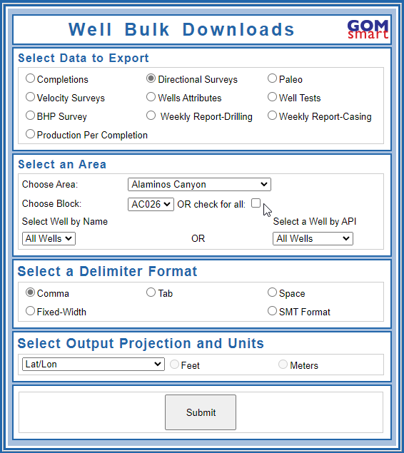
There are two tools that download many datasets related to wells. The Extract Data by Area tool, which is also available as the Bulk Well Data tool in GOMsmart, downloads basic well data, directional surveys, completions, production (per completion), paleo samples, velocity surveys, bottom-hole pressure surveys, well tests, casing data and weekly drilling samples. Data is chosen by drilling down through a selection of Protraction Areas, Blocks and Wells and is downloaded as a text file with different delimiters. The only caveat is that the directional survey and production downloads can be so large for a protraction area that there can be internet issues while waiting for the file to generate; we recommend not trying to download an entire protraction area for those two datasets.
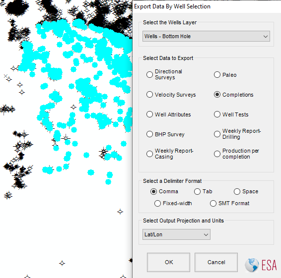
The second tool to download the various datasets of wells is the Extract Data by Selected Wells tool. This requires a number of wells to be selected (highlighted) in the map. After designating which layer to use at the top of the window (in case you have multiple layers of point data), you can export the same ten datasets as the Extract Data by Area tool. The tool will search through the API Numbers of the first 1,000 wells selected to download the selected dataset (due to size considerations, directional surveys and production is limited to the first 200 wells).
This tool exports the tabular data for a layer or standalone table in ArcMap or ArcScene to an Excel file. If certain records in the table are selected, only those will be exported. This tool was created because of the lack of an easy way to get data into Excel from ArcGIS. In ArcGIS Pro, the tool was not recreated because Pro has the Table to Excel tool available to do the exact same export (and with the same export of column aliases for readability).
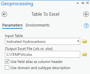 The Table to Excel tool in ArcGIS Pro with the field alias as column header option checked.
This tool quickly exports an image of the map or 3D scene and inserts it into a new slide in PowerPoint. If PowerPoint is already open, it will automatically add a new slide to insert the image, otherwise it will ask for a location to create a new PowerPoint Presentation. This is an efficient way to quickly get maps and scenes out to PowerPoint for different zoom levels and viewpoints.
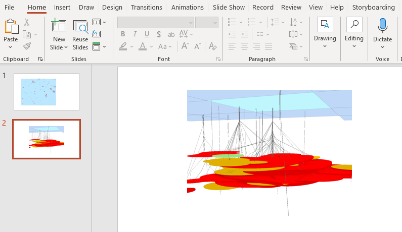
A map and 3D scene quickly exported to PowerPoint.
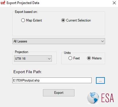
Many different applications can now read shapefiles, so simply exporting data from ArcGIS as a shapefile will be enough for many programs to import data. However, not all applications have the projection-on-the-fly capabilities of ArcGIS and it's important to have the data written in a way that will work with your project in other apps.
The Export Projected Data tool gives you the option of writing a shapefile into any of the seven coordinate systems used to survey the Gulf of Mexico, plus the default North American Datum in decimal degrees. Generally, projects in other apps will always have other data in one of these eight coordinate systems.
The Keyhole Markup Language (KML) was created by a company acquired by Google and has the advantages of other XML files. The Export to KML tool writes data from a chosen layer into a KML file, with options for transparency and labeling and advanced options for attribute exports and 3D properties.
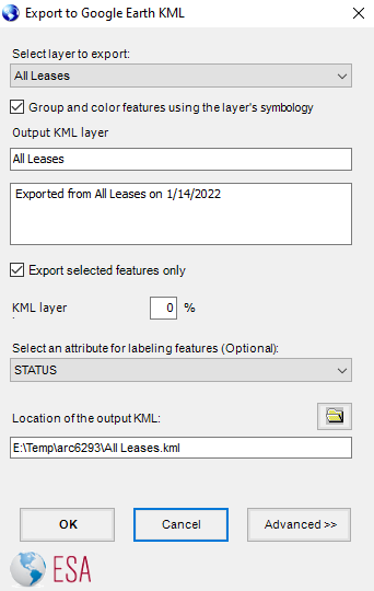 Exporting leases to KML with the basic properties (Advanced Options still collapsed).
Support for KML at Esri has increased over time, to the point that a Layer to KML tool was added to ArcMap and eventually ArcGIS Pro. Because of that, the Export to KML tool was not recreated in Pro.
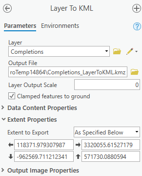 The Layer to KML tool in ArcGIS Pro exporting Completions.
The Convert Shape to Text tool was the original conversion tool, meant to export geographic shapes into a text file format that can be imported into various applications. Using the tool is simply a matter of choosing the layer and the output location for the text file. If there are selected features, only those will be exported. The output is in the format of the ID (based on the primary display field), the record number, the part number (if it is a multi-part line or polygon), the vertex number and the X and Y.
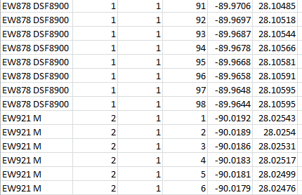 Text output of sands, shown in Excel.
The Export to SMT/Kingdom tool was created at the time that IHS was acquiring Kingdom, which created an obstacle to development. And at this point, because Kingdom handles shapefiles for its maps, we recommend using the Export Projected Data as the primary tool for most exports to Kingdom, along with the Extract Data by Area or by Selected Wells tools for directional survey data. If you would like to try the Export to SMT/Kingdom tool, it creates culture files for leases, blocks and platforms within the map extent, along with well locations and directional survey points.
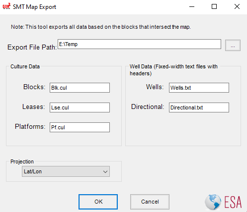 The Kingdom export dialog, writing to the E:\Temp directory with geographic decimal degree units.